English   Română   Español   Français   Deutsch  

getamap.net

Afrique

Oceanie

Asie

Amerique du Nord

Europe

Amerique du Sud

L'Antarctique


North Mayreau Channel

/ Grenadines

12°40'0" N
61°22'60" W
~0m asl
06:35 (AST - UTC/GMT--4)

North Mayreau Channel (North Mayreau Channel) est un/une canal maritime (class H - hydrographique) en Grenadines, Saint-vincent-et-les Grenadines (North America), ayant le code de région Americas/Western Europe...

Les coordonnées géographiques sont 12°40'0" N et 61°22'60" W en DMS (degrés, minutes, secondes) ou 12.6667 et -61.3833 (en degrés décimaux). La position UTM est PV70 et la référence Joint Operation Graphics est ND20-16.

L’heure locale actuelle est 06:35; le lever du soleil est à 08:53 et le coucher du soleil est à 21:00 heure locale (America/St_Vincent UTC/GMT-4). Le fuseau horaire pour North Mayreau Channel est UTC/GMT-4
En 2024 l’heure d’été est valable de - à -.

A Canal maritime est la partie d'un plan d'eau assez profond pour la navigation dans une région par ailleurs ne convient pas.


Country
 Advertisements:


 Advertisements:


Météo North Mayreau Channel (Nébulosité, Température, Vent et Précipitation mm probab.)

Sun


Apr 28
Clound 10-10-0-40
~1 l/m2 24%
 
27 °C min
28 °C max
28 km/h
Thu Jan 1

Mon


Apr 29
Clound 10-10-10-70
 
27 °C min
28 °C max
26 km/h
Thu Jan 1

Tue


Apr 30
Clound 20-10-10-40
~1 l/m2 29%
 
27 °C min
28 °C max
28 km/h
Thu Jan 1

Wed


May 1
Clound 10-30-0-20 Lightning
 
27 °C min
28 °C max
29 km/h
Thu Jan 1

Thu


May 2
Clound 20-10-40-60 Lightning
~4 l/m2 59%
 
27 °C min
29 °C max
27 km/h
Thu Jan 1

Fri


May 3
Clound 10-10-50-30 Lightning
 
27 °C min
29 °C max
26 km/h
Thu Jan 1

Météo Graph

North Mayreau Channel (Grenadines) prévisions à 7 jours
 

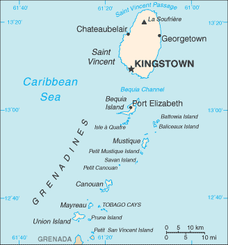
Carte et Les photos North Mayreau Channel


Commentaires

--- Il n'y a aucun commentaire ---


Ajouter un commentaire:


Vous devez vous connecter pour ajouter un commentaire!


Login


Register

Mot de passe oublié ?

Saint-vincent-et-les Grenadines (Kingstown):

Advertisement


Points GPS pres de North Mayreau Channel


square Mayaro Island (1 km)

square Mayero Island (1 km)

square Mayreau (1 km)

square Old Wall (3 km)

square Upper Bay (3 km)

square Dove Cay (4 km)

square L'Islot (4 km)


square Saline Bay (4 km)


square Tobago Cays (5 km)

square Charlestown (5 km)


square Petit Tobac (6 km)


Points GPS de Saint-vincent-et-les Grenadines (Kingstown)

square The Grenadines Grenadines

square Baleine Bay Parish Of Saint David


square Warrawarrou River Parish Of Saint George

square Saint Vincent Colony Saint Vincent And The Grenadines (general)

square Barrualli Parish Of Saint Patrick

square Belle Vue Parish Of Charlotte

square Old Woman Point Saint Vincent And The Grenadines (general)


viewweather.com sv.ViewWeather.com
fr.ViewWeather.com
da.ViewWeather.com
de.ViewWeather.com
es.ViewWeather.com
www.carpati.org
www.searchromania.net
Deblocari usi
es.getamap.org
fr.getamap.org
de.getamap.org
nl.getamap.org
da.getamap.org
www.getamap.org
Liens
Conditions d'utilisation
Politique de confidentialité

# 0.9068 sec 

contact AT getamap.net

© 2006 - 2024  https://fr.getamap.net/