English   Română   Español   Français   Deutsch  

getamap.net

Afrique

Oceanie

Asie

Amerique du Nord

Europe

Amerique du Sud

L'Antarctique


Narīboz

(Nari-buz) / Afghanistan (general)

33°19'27" N
69°32'27" E
~1,645m asl
05:57 (AFT - UTC/GMT+4.5)

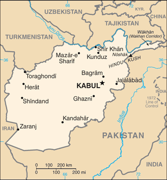
Nariboz (Narīboz) est un/une cours d'eau intermittent (class H - hydrographique) en Afghanistan (general), Afghanistan (Asia), ayant le code de région Russia/ Central Asia. Nariboz est situé à 1,645 mètres d'altitude.
Narīboz est aussi connu(e) comme Nari-Buz, Nari-buz, Nariboz, Naribuz, Narī-Buz, Narīboz, نريبز.

Les coordonnées géographiques sont 33°19'27" N et 69°32'27" E en DMS (degrés, minutes, secondes) ou 33.3242 et 69.5408 (en degrés décimaux). La position UTM est WB58 et la référence Joint Operation Graphics est NI42-11.

L’heure locale actuelle est 05:57; le lever du soleil est à 08:53 et le coucher du soleil est à 21:00 heure locale (Asia/Kabul UTC/GMT+4.5). Le fuseau horaire pour Nariboz est UTC/GMT+4.5
En 2024 l’heure d’été est valable de - à -.


Country
 Advertisements:


 Advertisements:


Météo Narīboz (Nébulosité, Température, Vent et Précipitation mm probab.)

Sun


Apr 28
Clound 50-10-90-60 Lightning
~2 l/m2 54%
 
8 °C min
9 °C max
12 km/h
Thu Jan 1

Mon


Apr 29
Clound 40-40-70-10
~14 l/m2 69%
 
4 °C min
10 °C max
14 km/h
Thu Jan 1

Tue


Apr 30
Clound 30-20-50-10
~10 l/m2 64%
 
4 °C min
9 °C max
25 km/h
Thu Jan 1

Wed


May 1
Clound 0-0-0-10
 
2 °C min
15 °C max
17 km/h
Thu Jan 1

Thu


May 2
Clound 0-0-0-40
 
6 °C min
18 °C max
12 km/h
Thu Jan 1

Fri


May 3
Clound 0-20-60-100
~2 l/m2 57%
 
10 °C min
18 °C max
12 km/h
Thu Jan 1

Météo Graph

Nari-buz (Afghanistan (general)) prévisions à 7 jours
 

Carte et Les photos Nariboz


Commentaires

--- Il n'y a aucun commentaire ---


Ajouter un commentaire:


Vous devez vous connecter pour ajouter un commentaire!


Login


Register

Mot de passe oublié ?

Afghanistan (Kabul):

Advertisement


Points GPS pres de Narīboz

square Khavikela' (0.5km)

square Khawikhel (0.5km)

square Savaykot (0.5km)

square Sawaykot (0.5km)

square Saway Kowt (0.5km)

square `Ala od Din (1 km)

square Alauddin (1 km)

square `Ala'uddin (1 km)

square Kamal'kote (1 km)

square Kamal Kote (1 km)

square Haram Kota (1 km)

square Haram Kowtah (1 km)

square Kharamkota (1 km)


square Khas Sapara (2 km)


Points GPS de Afghanistan (Kabul)


square Jare Dektor Samangan

square Nawah-e Nili Wilayat-e Ghor

square Spin Ghar Wilayat-e Paktika

square Kaz'yan Wilayat-e Parwan

square Sangar Kheyl Wilayat-e Logar

square Pamir Mountains Afghanistan (general)

square Jare Wadma Wilayat-e Daykundi


viewweather.com sv.ViewWeather.com
fr.ViewWeather.com
da.ViewWeather.com
de.ViewWeather.com
es.ViewWeather.com
www.carpati.org
www.searchromania.net
Deblocari usi
es.getamap.org
fr.getamap.org
de.getamap.org
nl.getamap.org
da.getamap.org
www.getamap.org
Liens
Conditions d'utilisation
Politique de confidentialité

# 0.0870 sec 

contact AT getamap.net

© 2006 - 2024  https://fr.getamap.net/