4°40'0" S
149°30'0" E
~141m asl
02:00 (PGT - UTC/GMT+10)
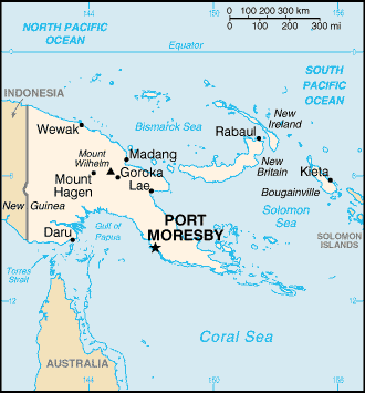
John Albert Harbor (John Albert Harbor) est un/une port (s) (class H - hydrographique) en West New Britain Province (West New Britain), Papouasie-nouvelle-guinée (Oceania), ayant le code de région Asia/Pacific. John Albert Harbor est situé à 141 mètres d'altitude.
John Albert Harbor est aussi connu(e) comme Johann Albrecht Harbour, John Albert Harbor.
Les coordonnées géographiques sont 4°40'0" S et 149°30'0" E en DMS (degrés, minutes, secondes) ou -4.66667 et 149.5 (en degrés décimaux). La position UTM est GQ78 et la référence Joint Operation Graphics est SB55-04.
L’heure locale actuelle est 02:00; le lever du soleil est à 08:53 et le coucher du soleil est à 21:00 heure locale (Pacific/Port_Moresby UTC/GMT+10). Le fuseau horaire pour John Albert Harbor est UTC/GMT+10
En 2024 l’heure d’été est valable de - à -.
A Port (s) est un havre de paix ou un espace d'eau profonde afin abrité par les terrains adjacents à permettre un mouillage sûr pour les navires.
|
Advertisements:
Advertisements:
|
Météo John Albert Harbor (Nébulosité, Température, Vent et Précipitation mm probab.)
Sun
Apr 28
29 °C min
30 °C max
16 km/h
Thu Jan 1
|
Mon
Apr 29
~12 l/m2 63%
28 °C min
30 °C max
20 km/h
Thu Jan 1
|
Tue
Apr 30
~8 l/m2 47%
28 °C min
30 °C max
15 km/h
Thu Jan 1
|
Wed
May 1
~25 l/m2 90%
26 °C min
30 °C max
20 km/h
Thu Jan 1
|
Thu
May 2
~11 l/m2 52%
28 °C min
30 °C max
11 km/h
Thu Jan 1
|
Fri
May 3
~11 l/m2 69%
28 °C min
30 °C max
18 km/h
Thu Jan 1
|
|
|
Johann Albrecht Harbour (West New Britain Province) prévisions à 7 jours
Carte et Les photos John Albert Harbor
--- Il n'y a aucun commentaire ---
Ajouter un commentaire:
|
Login
Papouasie-nouvelle-guinée (Port Moresby):
Advertisement
Points GPS pres de John Albert Harbor
Points GPS de Papouasie-nouvelle-guinée (Port Moresby)
|

 Potpot (1 km)
  Put Put (1 km)
  Ilia Bay (1 km)
  Lambe (1 km)
  Benukanare Island (2 km)
  Balangori Bay (3 km)
  Deslacs Island (3 km)
  Deslaos Island (3 km)
  East Entrance Cape (3 km)
  Garove Island (3 km)
  Garowe Island (3 km)
  Ile des Lacs (3 km)
  Witu (3 km)
  North Cape (3 km)
  Cape Bodobodo (4 km)
  Senta Bay (4 km)
  Tortoiseshell Bay (4 km)


