|
|
|
Advertisements:
GeographyLocation
Europe de l'Ouest, l'île dans la mer d'Irlande, entre la Grande-Bretagne et l'Irlande Geographic coordinates
54 15 N, 4 30 W
Map references
Europe
Area
Total 572 sq km
Land 572 sq km Water 0 sq km Area - comparative
Un peu plus de trois fois la superficie de Washington, DC Land boundaries
0 km
Coastline
160 km
Maritime claims
Territorial sea 12 nm
Exclusive fishing zone 12 nm Climate
Tempérées ; étés frais et des hivers doux ; ciel couvert environ un tiers du temps Terrain
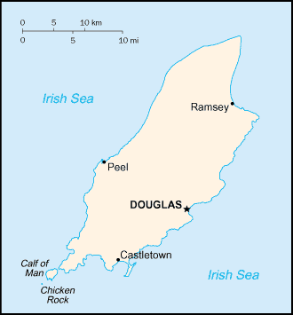
Collines au nord et le sud, traversée par la vallée centrale Elevation extremes
Lowest point Irish Sea 0 m
Highest point Snaefell 621 m Natural resources
None
Land use
Arable land 10%
Permanent crops 0% Other 90% (permanent pastures, forests, mountain, and heathland) (2002) Irrigated land
0 sq km
Natural hazards
NA
Environment - current issues
Déchets (ménagers et industriels) ; pollution atmosphérique transfrontière Geography - note
Un petit îlot, le veau de l'homme, dans le sud-ouest et est un refuge d'oiseaux
Commentaires
Ajouter un commentaire: |
Advertisement
Login
Isle Of Man [ Royaume-uni ] (British Crown Dependency):
Points GPS de Isle Of Man [ Royaume-uni ] (British Crown Dependency)
|
||||||||
 Partie du Royaume norvégien des Hébrides jusqu'au 13ème siècle quand elle fut cédée à l'Écosse, le MEAC isle sous la Couronne britannique en 1765. Préoccupations actuelles incluent faire revivre la langue gaélique mannois presque éteinte. Île de Man est une dépendance de la Couronne britannique, mais ne fait pas partie du Royaume-Uni ou de l'Union européenne. Toutefois, le gouvernement britannique demeure constitutionnellement responsable de sa défense et représentation internationale.