English   Română   Español   Français   Deutsch  

getamap.net

Afrique

Oceanie

Asie

Amerique du Nord

Europe

Amerique du Sud

L'Antarctique


Chumpang Bay

/ Singapore (general)

1°15'32" N
103°48'47" E
~1m asl
12:48 (SGT - UTC/GMT+8)

Chumpang Bay (Chumpang Bay) est un/une crique (s) (class H - hydrographique) en Singapore (general), Singapour (Asia), ayant le code de région Asia/Pacific. Chumpang Bay est situé à 1 mètres d'altitude.

Les coordonnées géographiques sont 1°15'32" N et 103°48'47" E en DMS (degrés, minutes, secondes) ou 1.25889 et 103.813 (en degrés décimaux). La position UTM est UG63 et la référence Joint Operation Graphics est NA48-10.

L’heure locale actuelle est 12:48; le lever du soleil est à 08:54 et le coucher du soleil est à 21:01 heure locale (Asia/Singapore UTC/GMT+8). Le fuseau horaire pour Chumpang Bay est UTC/GMT+8
En 2024 l’heure d’été est valable de - à -.

A Crique (s) est une petite empreinte côtières, plus petit qu'une baie.


Country
 Advertisements:


 Advertisements:


Météo Chumpang Bay (Nébulosité, Température, Vent et Précipitation mm probab.)

Thu


Apr 25
Clound 20-10-20-70 Lightning
~9 l/m2 38%
 
27 °C min
32 °C max
15 km/h
Thu Jan 1

Fri


Apr 26
Clound 20-10-30-100 Lightning
~11 l/m2 53%
 
26 °C min
31 °C max
9 km/h
Thu Jan 1

Sat


Apr 27
Clound 0-10-30-100 Lightning
~3 l/m2 30%
 
27 °C min
32 °C max
11 km/h
Thu Jan 1

Sun


Apr 28
Clound 0-10-0-100
~5 l/m2 28%
 
27 °C min
32 °C max
12 km/h
Thu Jan 1

Mon


Apr 29
Clound 20-10-50-100 Lightning
~8 l/m2 57%
 
27 °C min
30 °C max
15 km/h
Thu Jan 1

Tue


Apr 30
Clound 0-10-80-100 Lightning
 
27 °C min
32 °C max
12 km/h
Thu Jan 1

Météo Graph

Chumpang Bay (Singapore (general)) prévisions à 7 jours
 

Carte et Les photos Chumpang Bay


Commentaires

--- Il n'y a aucun commentaire ---


Ajouter un commentaire:


Vous devez vous connecter pour ajouter un commentaire!


Login


Register

Mot de passe oublié ?

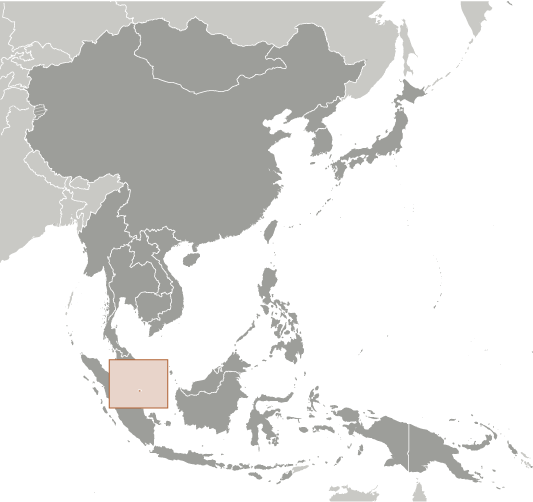
Singapour (City-state):

Advertisement


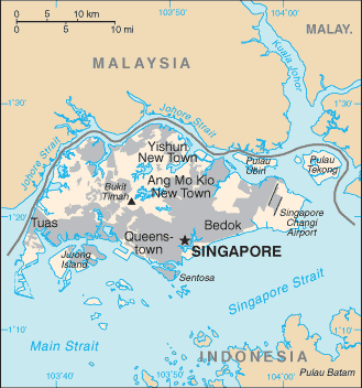
Points GPS pres de Chumpang Bay

square Chumpang Bay (0.5km)

square Pulau Renggis (0.5km)

square Cruise Bay (0.5km)

square Mount Embiah (0.5km)

square Mount Imbiah (0.5km)

square Fort Siloso (0.5km)

square Mount Siloso (0.5km)

square Sarang Rimau (0.5km)

square Pulau Hantu (0.5km)

square Pulau Keppel (0.5km)

square Pulau Selegu (0.5km)

square King's Dock (0.5km)

square Siloso Beach (0.5km)

square Tanjong Rimau (0.5km)

square Queen's Dock (0.5km)

square Bukit Chermin (0.5km)

square Chermin Wharf (0.5km)


Points GPS de Singapour (City-state)

square Tanjong Mak Aerik Singapore (general)

square Simpang Bedok Singapore (general)

square Pulau Pesek Kecil Singapore (general)

square Tanjong Romos Singapore (general)

square Tanglin Hill Singapore (general)

square Sommerville Estate Singapore (general)

square Murai Reservoir Singapore (general)

square Bukit Sembawang Estate Singapore (general)


viewweather.com sv.ViewWeather.com
fr.ViewWeather.com
da.ViewWeather.com
de.ViewWeather.com
es.ViewWeather.com
www.carpati.org
www.searchromania.net
Deblocari usi
es.getamap.org
fr.getamap.org
de.getamap.org
nl.getamap.org
da.getamap.org
www.getamap.org
Liens
Conditions d'utilisation
Politique de confidentialité

# 0.0692 sec 

contact AT getamap.net

© 2006 - 2024  https://fr.getamap.net/