English   Română   Español   Français   Deutsch  

getamap.net

Afrique

Oceanie

Asie

Amerique du Nord

Europe

Amerique du Sud

L'Antarctique


5°42'0" N
57°48'0" W
~22m asl
15:22 (GYT - UTC/GMT--4)

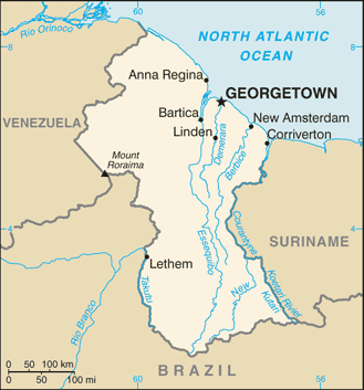
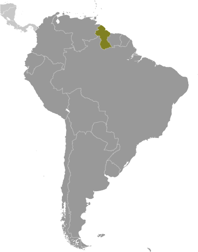
Hollandia (Hollandia) est un/une immobilier (s) (class S - Dossier Spot) en Upper Demerara-Berbice Region (Upper Demerara-Berbice), Guyana (South America), ayant le code de région Americas/Western Europe. Hollandia est situé à 22 mètres d'altitude.

Les coordonnées géographiques sont 5°42'0" N et 57°48'0" W en DMS (degrés, minutes, secondes) ou 5.7 et -57.8 (en degrés décimaux). La position UTM est VG13 et la référence Joint Operation Graphics est NB21-10.

L’heure locale actuelle est 15:22; le lever du soleil est à 08:54 et le coucher du soleil est à 21:01 heure locale (America/Guyana UTC/GMT-4). Le fuseau horaire pour Hollandia est UTC/GMT-4
En 2024 l’heure d’été est valable de - à -.

A Immobilier (s) est une grande propriété foncière agricole commercialisée avec des bâtiments et des installations d'autres.


Country
 Advertisements:


 Advertisements:


Météo Hollandia (Nébulosité, Température, Vent et Précipitation mm probab.)

Thu


Apr 25
Clound 10-20-0-100
 
23 °C min
33 °C max
10 km/h
Thu Jan 1

Fri


Apr 26
Clound 10-40-0-70 Lightning
~0.3 l/m2 21%
 
21 °C min
35 °C max
12 km/h
Thu Jan 1

Sat


Apr 27
Clound 20-50-10-40 Mist Lightning
~3 l/m2 48%
 
23 °C min
32 °C max
10 km/h
Thu Jan 1

Sun


Apr 28
Clound 30-50-10-40 Mist Lightning
~9 l/m2 50%
 
22 °C min
32 °C max
10 km/h
Thu Jan 1

Mon


Apr 29
Clound 30-40-20-40 Lightning
~10 l/m2 58%
 
23 °C min
31 °C max
10 km/h
Thu Jan 1

Tue


Apr 30
Clound 30-50-30-40 Mist Lightning
~7 l/m2 53%
 
23 °C min
32 °C max
11 km/h
Thu Jan 1

Météo Graph

Hollandia (Upper Demerara-Berbice Region) prévisions à 7 jours
 

Carte et Les photos Hollandia


Commentaires

--- Il n'y a aucun commentaire ---


Ajouter un commentaire:


Vous devez vous connecter pour ajouter un commentaire!


Login


Register

Mot de passe oublié ?

Guyana (Georgetown):

Advertisement


Points GPS pres de Hollandia

square Capelle (1 km)

square Copelle (1 km)

square Hogstraten (1 km)

square Hoogstraten (1 km)


square Lilienburg (1 km)

square Lillenburg (1 km)

square Saints Lust (1 km)


square Kaiuwa Creek (1 km)

square De Vreede (2 km)

square Essendam (2 km)

square Juliana (2 km)

square Kimbia River (3 km)


Points GPS de Guyana (Georgetown)

square Kasarama Creek Upper Demerara-berbice Region

square Kaieteur Fall Potaro-siparuni Region

square Turtle Mountain Potaro-siparuni Region

square Kaburi Rock Cuyuni-mazaruni Region

square Sand Hills Upper Demerara-berbice Region

square Atabu Creek Pomeroon-supenaam Region

square Mount Egerton Upper Takutu-upper Essequibo Region

square Kowanaparu Creek Cuyuni-mazaruni Region


viewweather.com sv.ViewWeather.com
fr.ViewWeather.com
da.ViewWeather.com
de.ViewWeather.com
es.ViewWeather.com
www.carpati.org
www.searchromania.net
Deblocari usi
es.getamap.org
fr.getamap.org
de.getamap.org
nl.getamap.org
da.getamap.org
www.getamap.org
Liens
Conditions d'utilisation
Politique de confidentialité

# 0.9299 sec 

contact AT getamap.net

© 2006 - 2024  https://fr.getamap.net/