62°0'0" N
7°0'0" W
~58m asl
06:17 (WEST - UTC/GMT+1)
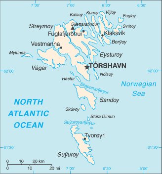
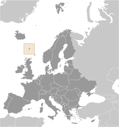
Die Far Oer (Die Fär Oer) est un/une îles (class T - hypsographiques) en Faroe Islands (general), îles Féroé [ Danemark ] (Europe), ayant le code de région Americas/Western Europe. Die Far Oer est situé à 58 mètres d'altitude et la population s'élève à 48,228.
Die Fär Oer est aussi connu(e) comme Faeaeri saared, Faeaerooerne, Faereyjar, Faero, Faeroe Islands, Faeroearna, Faeroeer, Faeroeer-Inseln, Faeroerne, Faeroyane, Faeroyene, Faersaaret, Faerske ostrovy, Faerské ostrovy, Faeröer, Far'orski O-vi, Far'orski ostrovi, Farao-szigetek, Farer araldary, Farerskia vyspy, Farerskie ostrova, Fareru salos, Farerų salos, Faroe Adalari, Faroe Adaları, Faroe Islands, Faroe uharteak, Faroe, isole, Faroereilande, Faroëreilande, Farska Ostrva, Farska ostrva, Farski Ostrovi, Farski Otoci, Fearsullot, Feroe Uharteak, Feroe nga Islas, Feroeer, Ferojski otoci, Ferooj, Ferski otoki, Fersko otocje, Fersko otočje, Feru salas, Feröer, Foroyar, Fáraó-szigetek, Färsaaret, Färöarna, Färöer, Färöer-Inseln, Fääri saared, Fæaerøoerne, Færeyjar, Færøerne, Færøyane, Færøyene, Føroyar, Fēru salas, Giraven Faroe, Giravên Faroe, Gzejjer Faroe, Gżejjer Faroe, Iles Feroe, Iles Fèroè, Iles Féroé, Ilhas Faroe, Ilhas Faroé, Ilhas Feroe, Ilhas Feroé, Illas Faroe, Illas Feroe, Illas Feroe - Foroyar, Illas Feroe - Føroyar, Illas Feroé, Illas Feròe, Illes Feroe, Illes Fèroe, Insulas Feroe, Insulele Faroe, Insulele Feroe, Ishujt Faroe, Islas Feroe, Islles Feroe, Isole Faer Oer, Isole Fær Øer, Kepulauan Faroe, Nesia Pharoe, Nesoi Pheroes, Oileain Fharo, Oileáin Fharó, Ostrovi Faro, Quan GJao Faroe, Quần Đảo Faroe, Wyspy Owcze, Ynysoedd Ffaroee, Ynysoedd Ffaröe, Ynysow Faroe, fa luo qun dao, fairo a'ilaindsa, fero zhu dao, hmu keaa far ro, jzayrfarw, jzr farw, jzyrh hay farwh, palo-e gundo, pelo jedo, phyaro dbipapunja, Îles Féroé, Νήσοι Φερόες, Νησιά Φαρόε, Острови Фаро, Фарер аралдары, Фарерские острова, Фарерські острови, Фарска Острва, Фарска острва, Фарски Острови, Фарьорски О-ви, Фарьорски острови, Фарэрскія выспы, איי פארו, פרואר, איי, جزائرفارو, جزر فارو, جزیره های فاروه, फ़ैरो आइलैंड्स, ফ্যারো দ্বীপপুঞ্জ, หมู่เกาะฟาร์โร, หมู่เกาะแฟโร, ფარერის კუნძულები, ფაროს კუნძულები, የፋሮይ ደሴቶች, ፋሮ ደሴቶች, フェロー諸島, 法罗群岛, 파로에 군도, 페로 제도.
Les coordonnées géographiques sont 62°0'0" N et 7°0'0" W en DMS (degrés, minutes, secondes) ou 62 et -7 (en degrés décimaux). La position UTM est PJ07 et la référence Joint Operation Graphics est NP29-06.
L’heure locale actuelle est 06:17; le lever du soleil est à 07:55 et le coucher du soleil est à 20:02 heure locale (Atlantic/Faeroe UTC/GMT+1). Le fuseau horaire pour Die Far Oer est UTC/GMT+0, mais le fuseau horaire actuel est UTC/GMT+1, parce qu’en ce moment l’heure d’été (DST) est valable.
En 2024 l’heure d’été est valable de 31 Mar 2024 à 27 Oct 2024.
A îles est étendues de terre, plus petite qu'un continent, entourée par l'eau à marée haute.
|
Advertisements:
Advertisements:
|
 Hammer (0.5km)